La ICTS SOCIB opera un sistema de observación multiplataforma, recabando datos meteoceánicos desde la costa hasta mar abierto, además de un sistema de predicción oceánica, de oleaje y meteotsunamis.
Instalaciones de observación de la ICTS SOCIB
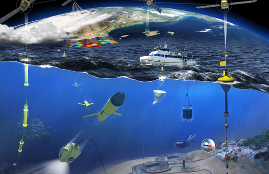
El sistema de observación de la ICTS SOCIB incluye boyas de deriva superficial y perfiladores, 16 estaciones costeras instaladas en distintos puertos y/o zonas costeras de las Illes Balears, 2 boyas meteoceánicas instaladas en el canal de Ibiza y la bahía de Palma, un Buque Oceanográfico (B/O SOCIB) de 24 m de eslora, 2 estaciones de radar costero de alta frecuencia (HF), una flota de 7 planeadores submarinos autónomos (gliders) y 3 sistemas de monitorización de playas.
Accede a las instalaciones de observación


La importancia de las infraestructuras de observación del océano
Las infraestructuras de observación del océano, como la ICTS SOCIB, han cobrado especial relevancia en los últimos años. Estas ofrecen datos del océano de forma continua, en acceso abierto y en tiempo real, para mejorar el conocimiento, la predicción y la gestión de los recursos marinos y costeros en un contexto de cambio global. Para ello, realizan una monitorización sostenida del océano los 365 días del año, 24 horas al día, y responden a un cambio de paradigma en la investigación oceanográfica.
A partir de la década de los años 80, la oceanografía experimentó una transformación radical. Hasta ese momento, el principal medio para obtener datos del océano eran los buques oceanográficos, y lo hacían, a través de largas y costosas campañas oceanográficas. Los datos obtenidos eran parciales e insuficientes para entender los complejos procesos que ocurrían en el océano. Fue entonces cuando la observación oceánica, gracias a los avances tecnológicos, cambió.
De obtener datos desde una única plataforma (buques oceanográficos) los oceanógrafos y oceanógrafas pudieron monitorizar de forma permanente el océano utilizando múltiples plataformas, instrumentos y tecnologías de observación in situ, en la costa o desde el espacio, a través de satélites específicamente diseñados para investigación oceanográfica. Es lo que se conoce actualmente como observación oceánica multiplataforma.
Los sistemas multiplataforma de observación del océano desempeñan un papel clave para afrontar múltiples desafíos como, por ejemplo, comprender el estado del océano y su variabilidad (desde pequeñas hasta grandes escalas), facilitar la predicción de escenarios climáticos, establecer mecanismos de alerta temprana ante eventos extremos o realizar planes de adaptación costera, entre otros. Estos datos se ofrecen desde infraestructuras como la ICTS SOCIB, en acceso abierto y en tiempo real, para contribuir a avanzar en la comprensión del océano y lograr que este conocimiento repercuta en la toma de decisiones, promoviendo así una gestión marina basada en la evidencia científica.
La ICTS SOCIB se alinea con el Foro de Estrategia Europea sobre Infraestructuras de Investigación (ESFRI) y el Sistema Europeo de Observación Oceánica (EuroGOOS) para asegurar observaciones sostenidas a largo plazo en los mares de Europa y garantizar el acceso a los datos en beneficio de la sociedad, la ciencia y la innovación.

Plataformas y redes de observación del océano in situ, julio de 2023.
Fuente: Global Ocean Observing System (GOOS), Ocean Observing System Report Card 2023.